 comparison
Aerial Footage vs Accurate Property Views: Fast Delivery
Table of Contents
- Aerial Footage vs Accurate Property Views: What Sets Them Apart
- Cinematic Impact: When Stunning Aerial Footage Wins
- Documentation Accuracy: The Case for Detailed Property Views
- Types of Aerial Photography Shots and Their Real Estate Applications
- Real Estate Drone Video: Engagement and Storytelling
- Aerial Real Estate Photography Rates and Fast Drone Media Delivery
- Choosing the Right Approach for Your Property Type and Goals
- Frequently Asked Questions
Last Updated: October 10, 2026
Aerial Footage vs Accurate Property Views: What Sets Them Apart
Marketing a property requires choosing between stunning aerial footage for impact or detailed aerial footage property views for documentation. At Phoenix Drone Pros, we help real estate agents, developers, and property managers make this decision based on property type, timeline, and audience needs.
Cinematic aerial video generates engagement but costs more; detailed documentation costs less but serves inspection and verification purposes. Choosing the right approach determines listing speed and market performance.
Cinematic Impact: When Stunning Aerial Footage Wins
Stunning aerial footage creates emotional connection that ground-level photos cannot match, positioning properties as special and aspirational.
This works best for high-end residential properties and commercial developments where setting matters. Buyers of $2M+ properties expect cinematic presentation showing context, views, landscaping, and neighborhood prestige.
Properties with aerial video get more clicks, longer listing page time, and more qualified showings, creating urgency before prospects visit.
However, stunning aerial footage doesn't document condition, it won't show roof damage, foundation cracks, or structural issues that require inspection.
Documentation Accuracy: The Case for Detailed Property Views
Detailed, accurate property views support measurable decisions and verification, though aerial imagery has accuracy limits for inspections and legal documentation.
Drone imagery excels at providing aerial footage property views that show overall condition, layout, and spatial relationships. For commercial properties, it documents all sides, parking condition, and landscaping. For construction, aerial photos create timestamped records of site conditions and progress, more useful than ground-level photos for tracking development.
But there are specific accuracy constraints:
Measurement and scale: Drone imagery shows relative size and distance, but precise measurements require ground surveys or 3D mapping. Roofs appear in clear detail from 150 feet, but exact dimensions or hairline cracks require closer inspection or post-processing.
Perspective and lens distortion: Wide-angle drone lenses create perspective distortion that exaggerates depth. Detailed documentation uses multiple angles and consistent altitude to reduce distortion. Thermal inspections require specific altitude and angle for reliable data.
Lighting and weather conditions: Accurate documentation requires consistent lighting and clear skies. Professional shoots happen in midday sun to maximize visibility. Rush shoots in poor conditions produce lower-quality documentation than scheduled shoots with optimal weather.
What drone imagery reliably shows: Overall condition, roof pitch, landscaping, boundaries, construction progress, and visible damage. What it does not reliably show: Precise measurements, subsurface conditions, interior defects, exact material specs, or small-scale damage without post-processing.
For insurance, property management, and construction oversight, this accuracy level is essential. Contractors use aerial photos for overall state, then supplement with ground inspection. Insurance companies use aerial footage to document damage extent, then send adjusters for details. Property managers use consistent documentation to monitor condition changes.
Detailed property views lack cinematic appeal but provide functional accuracy for construction sites, investment properties, insurance documentation, and facility management. Pair them with ground-level inspection when precision is critical.
Types of Aerial Photography Shots and Their Real Estate Applications
Real estate drone photography includes distinct shot types: Establishing shots show full property and surroundings for context. Orbit shots circle the property for dynamic video. Flyover shots show progression and scale. Roof documentation shots focus on condition, pitch, materials, and damage. Establishing shots and orbits create cinematic engagement; roof and side documentation provide inspection accuracy.
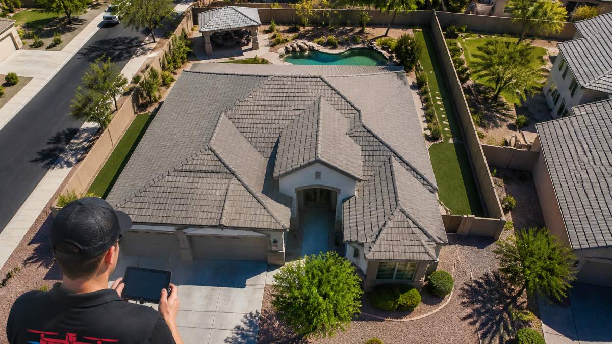
For listings, combine cinematic shots for appeal with detailed shots of each side, roof, and landscaping for buyer and agent information.
Real Estate Drone Video: Engagement and Storytelling
Real estate drone video creates engagement that static photography cannot match. A 60-90 second video with aerial footage, interior cuts, and neighborhood context keeps prospects engaged longer than photo galleries and creates emotional connection.
Fast delivery is critical, a video shot Monday arriving Thursday is useful; arriving two weeks later loses momentum. A straightforward video delivers next-day; heavily edited, color-graded, music-scored video takes longer. Choose based on your purpose. For agents and developers who need to move listings quickly, Video Offering Memorandum services provide professional aerial documentation tailored to commercial real estate marketing and investor presentations.
Aerial Real Estate Photography Rates and Fast Drone Media Delivery
Pricing depends on complexity, turnaround time, and deliverables. Understanding fast delivery requires knowing what happens between shoot and final files, and where speed creates trade-offs.
Understanding Pricing Factors
Pricing depends on property size and complexity.
Next-day delivery costs more than standard turnaround. Rush delivery costs substantially more due to immediate editing requirements.
Property type affects cost: single-family homes cost less than complex commercial sites or difficult terrain. Thermal inspections and 3D mapping add to the cost depending on size and accuracy requirements.
What Happens Between Shoot and Delivery: The Fast Delivery Workflow
Fast delivery is achievable, but only for specific deliverables. Understanding the workflow explains why some requests take longer than others.
Standard aerial photos (next-day delivery): Drone captures 50-200 raw images in 15-30 minutes. Editor selects best 8-15, applies color correction, and exports high-resolution files (4K or 6K, 20-50 MB each) in 2-4 hours. Files delivered as JPEGs for MLS and RAW files for archive.
Property video (next-day delivery): Raw drone video footage is typically 4K resolution, 100+ GB for a 15-30 minute flight. The editor selects 3-5 minutes of the best footage, cuts it into a 60-90 second sequence, applies color grading (adjusting color tone and brightness for visual consistency), and adds titles or simple graphics.
Thermal inspection report (2-3 days): Thermal cameras capture heat signatures that require specialized software to interpret. The technician flies the property, captures thermal video, then processes the footage to identify heat loss patterns, moisture issues, or electrical problems. The report includes thermal images, analysis, and recommendations.
3D property map or orthomosaic (5-7 days): Creating an accurate, georeferenced map requires 100+ overlapping images, specialized software (photogrammetry), and ground-truth calibration. The software stitches images together, calculates precise coordinates, and produces a map accurate to within a few inches. This process is computation-intensive and cannot be rushed.
Cinematic video with color grading and music (3-5 days): A premium video includes multiple shot types (establishing shots, orbits, flyovers), interior cuts, color grading (professional color correction), music licensing, and sometimes voiceover or text overlays. Each of these stages adds time. Color grading alone can take 4-8 hours for a 90-second video.
Fast Delivery Trade-Offs
Speed and quality are not always aligned. A video delivered in 24 hours will have minimal color grading and no music (or royalty-free music without licensing). A video delivered in 5 days can include professional color grading, licensed music, and multiple editing passes. For real estate listings, next-day delivery is often sufficient, the goal is to get the property online quickly, not to produce a film-festival-quality video.
For construction documentation or insurance purposes, accuracy matters more than speed. A thermal inspection rushed to 24 hours may miss subtle issues that a thorough 2-3 day analysis would catch. A 3D map rushed to 3 days may have alignment errors that a 7-day process would eliminate.
Fast Drone Media Delivery Expectations
Fast drone media delivery means next-day turnaround from shoot to final files for standard photography and video. You shoot Monday, files arrive Tuesday. This speed is critical for competitive real estate markets where timing determines whether a property gets shown or sits. In markets where multiple offers happen within 48 hours of listing, next-day aerial footage can be the difference between a property getting attention and being overlooked.
However, "next-day" has conditions:
- Weather: The shoot must happen in good conditions. A property scheduled for Monday that gets rained out doesn't deliver Tuesday. Professional services typically offer rescheduling at no charge, but the timeline shifts.
- File format: Next-day delivery includes standard formats (JPEGs, MP4 video). If you need RAW files, specialized formats, or additional processing, add 1-2 days.
- Revisions: If you request changes after delivery (different color tone, different music, additional editing), add 1-2 days per revision round.
- Complexity: A straightforward residential property delivers next-day. A large commercial site with multiple buildings, or a property requiring thermal imaging, may take 2-3 days even with expedited service.
The real value of fast delivery is momentum. A property listed with professional aerial footage within 24 hours of the shoot competes harder than one that waits a week. In competitive markets, that speed difference matters. But fast delivery is not free, expect to pay more for next-day service than for standard turnaround. Investing in this accelerated workflow remains a strategic decision when weighing the professional photography value against the long-term impact of a listing's initial market presence.
| Deliverable | Typical Turnaround | Best For | Editing Complexity | Cost Premium for Next-Day |
|---|---|---|---|---|
| Aerial photos (8-15 images) | Next day | Listing marketing | Low (color correction only) | 20-30% |
| Property video (60-90 sec, no music) | Next day | Engagement, MLS | Low (basic cuts and color) | 20-30% |
| Property video (with music and grading) | 2-3 days | Premium marketing | Medium (color grading, music licensing) | 30-50% |
| Thermal inspection report | 2-3 days | Roof condition, insurance | High (specialized analysis) | Not typically rushed |
| 3D property map | 5-7 days | Construction, site planning | Very High (photogrammetry processing) | Not typically rushed |
| Cinematic video (fully produced) | 3-5 days | Premium marketing, social media | Very High (multiple edits, color, music, effects) | 40-60% |
Choosing the Right Approach for Your Property Type and Goals
The decision between stunning aerial footage and detailed property views depends on what you're actually trying to accomplish.
Choose stunning aerial footage if: you're marketing a high-end residential property where setting and prestige matter, you need to drive emotional engagement and listing views, you're competing in a luxury market where cinematic presentation is expected, or you want video content that performs well on social media and MLS platforms.
Choose detailed property views if: you're documenting construction progress, you need roof or structural inspections, you're assessing property condition for insurance or investment purposes, you need accurate measurements or boundary documentation, or you're managing multiple properties and need consistent baseline documentation over time.
The reality is many properties benefit from both. A luxury home gets the cinematic aerial video for marketing impact. The same property might also get a detailed roof inspection if the listing mentions recent work or if the buyer's inspection raises questions.
Phoenix Drone Pros handles both approaches because different properties need different solutions. Our team holds FAA Part 107 certification, and operators can pursue advanced credentials through Done flight training to stay current with evolving regulations and techniques.
The decision between cinematic impact and documentation accuracy shapes how your property is presented and understood. Properties that need to move fast benefit from professional aerial footage delivered within 24 hours. Phoenix Drone Pros delivers both with FAA certification, full insurance, and over a decade of commercial experience. Learn more about aerial photography for real estate marketing.
Frequently Asked Questions
What is the difference between aerial footage and accurate property documentation?
Aerial footage emphasizes visual storytelling and cinematic appeal, capturing dramatic angles and context that engage viewers emotionally. Accurate property documentation prioritizes precision measurements, structural details, and exact boundary lines for verification and decision-making. Aerial footage attracts buyers through immersive visuals; accurate views provide the factual foundation they need before making an offer. Most high-end listings benefit from both approaches working together.
How quickly can real estate drone photos and videos be delivered?
Delivery speed depends on project scope, editing complexity, and the service provider's workflow. Professional drone operators can typically deliver edited aerial photos within 24-48 hours of the shoot, while cinematic video with color grading and transitions may take 3-7 business days. Fast drone media delivery requires clear upfront expectations about file formats, resolution, and revision rounds. Confirm turnaround time before booking to ensure the timeline matches your listing launch schedule.
When should I choose aerial drone video instead of static aerial photos for a property listing?
Use aerial drone video for luxury properties where visual storytelling drives buyer engagement, properties with significant outdoor features or views, and listings in competitive markets where cinematic presentation matters. Choose static aerial photos for documentation, construction progress tracking, or when you need faster delivery and lower costs. Many agents use both: video for emotional impact in marketing materials and high-resolution photos for MLS listings and detailed property records.
How do aerial real estate photography rates vary by property type and deliverable?
Aerial real estate photography rates depend on property size, complexity, location, and what you're ordering. Residential listings typically cost less than commercial or multi-building projects. Single aerial photos cost less than edited video packages. Rush delivery or specialized shots (thermal imaging, 3D mapping) add to the price. Pricing also reflects the operator's experience, equipment quality, and insurance. Contact providers directly for current quotes tailored to your specific project needs.